What's the Sperrgebiet...

and why can't we go there?

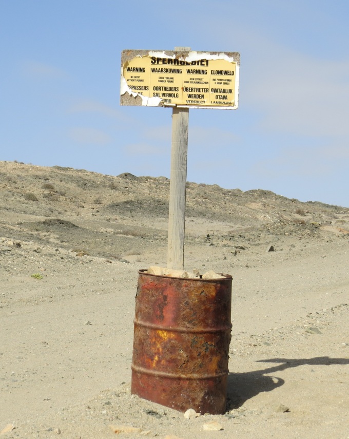
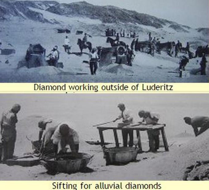
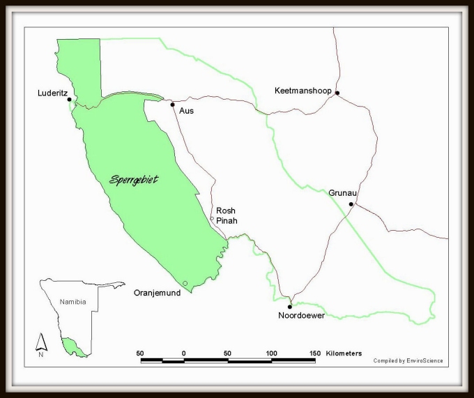
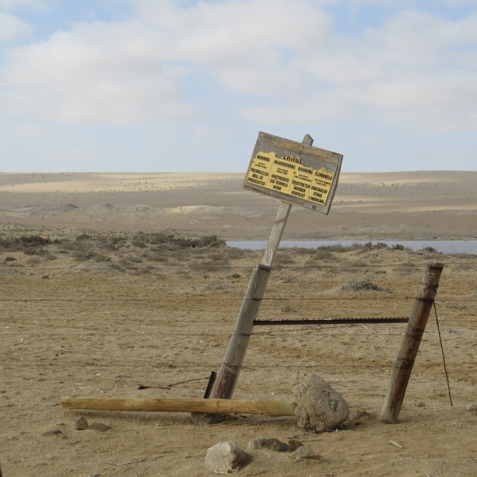
Sperrgebiet (pronounced spur-geh-beet) translates from the German to “Forbidden Area”. It's also known as Diamond Area 1 and it's the exclusive diamond mining area of southwestern Namibia. It extends along the Namibian coast from the South African border at Oranjemund for about 200 miles (320km) north ... about 45 miles north of Luderitz. It covers about 10,400mi² (26,000km²) in land area and the public has not been allowed within its boundaries without a special permit since 1908 when it was created.  It extends inland about 100km (60 miles) and out into the Atlantic Ocean about 5-6 miles. We noted “Restricted Area – Marine Mining Vessels – Entry Prohibited – Minefields” warnings on our charts all the way up the coast to Luderitz. There are no ports or anchorages along this stretch of coast at which we were allowed to stop.

sperrgebiet route map

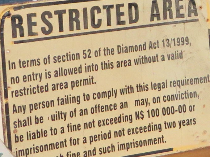
The German government originally created the Sperrgebiet in 1908 in  its German South West Africa colony, after diamonds were first discovered.  During WWI, Germany lost the territory to South Africa and the South African government gave control of the mining rights to DeBeers. After Namibia's independence, Namibia partnered 50/50 with DeBeers to form Namdeb Diamond Corporation. Sperggebiet remains. In fact, Namibia's Diamond Act of 1999, very explicitly outlines the rights of the diamond mining industry, the allowed legal actions of diamond inspectors and the laws governing uncut diamonds, as well as the penalties for possessing them illegally … stiff fines and lengthy imprisonment. I read that “some people in Namibia serve longer sentences for diamond theft than others do for murder”.

diamond theft hurts everyone

The town of Oranjemund located in the Sperggebiet is still inaccessible without a permit which “necessitates the submission of a police clearance document from your country of origin and can entail some months wait for Namibian authorities to approve the visit application.”

warning

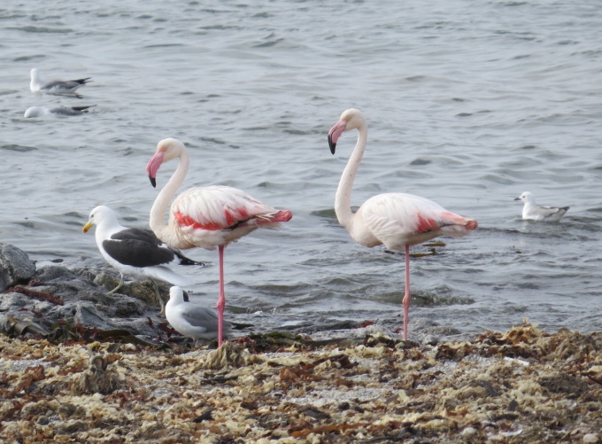
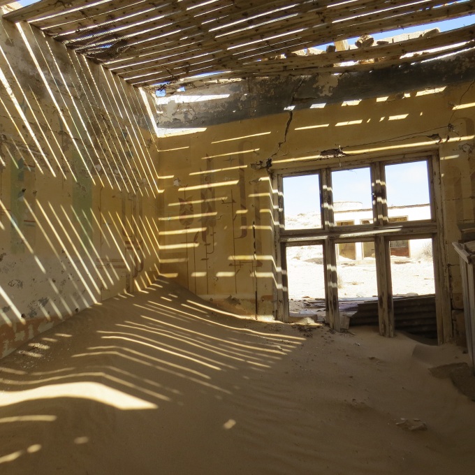
The diamond-mining industry has certainly left its mark on the area. Open-pit mining, spoil heaps and subsequent erosion and pollution, especially now along the coast, have done significant damage. On the other hand, only about 5% of the Sperggebiet is actually actively mined, the rest acts as kind of a buffer territory. The public exclusion from the area for decades has maintained much of the area as untouched. Granted it's semi-desert and desolate, but in actuality, it's a bio-diversity “hot-spot”. “About 1,050 plant species are found in the Sperrgebiet, which is 25 percent of the entire flora of Namibia. Fifty-six vegetation types have been identified, 35 coastal and marine bird species, 60 wetland bird species and 120 terrestrial bird species. There are 80 terrestrial and 38 marine mammal species, including 600,000 Cape fur seals, representing 50% of the world's seal population. Other wildlife includes 100 reptile species and 16 frog species.”

sperrgebiet_restricted area sign Diamond Act 1999

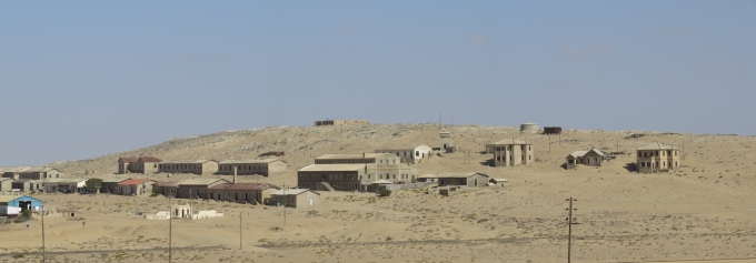
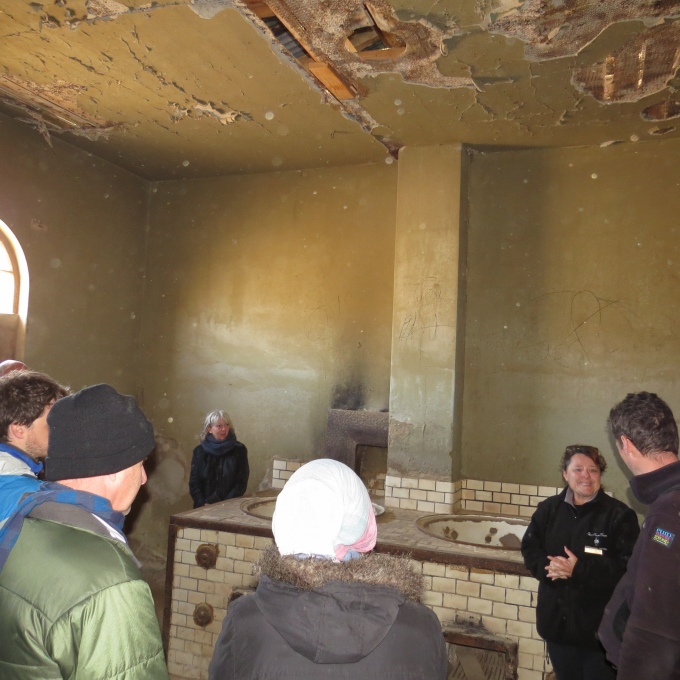
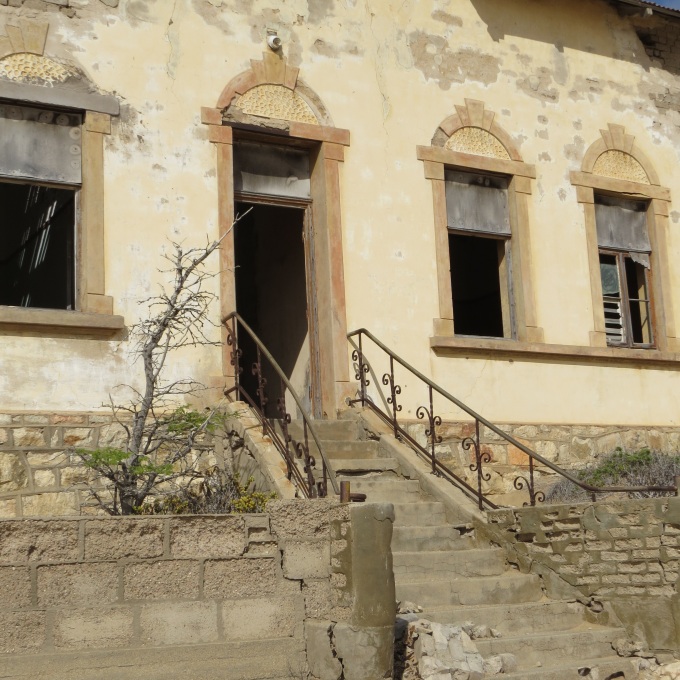
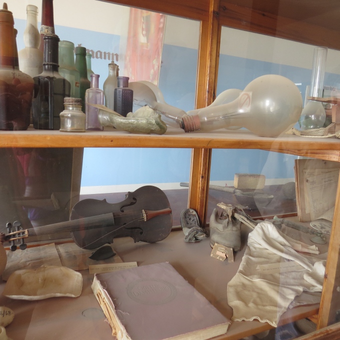
In 2004, Namdeb tranferred control of a large section of the Sperrgebiet to the Namibian government with the intent of reclaiming and re-vegetating the land and creating Sperggebiet National Park. In 2009, the park was formally opened, however unless you have a permit (which can take upwards of a week) and go with a nationally certified tour guide (there's only one in Luderitz), you are still not allowed to enter. We looked into the cost of taking the tour. They require a minimum of four people for the 8-hour tour and the cost is a whopping N$1,500/pp (~$US130/pp) for a marginal look at the area … a couple of ghost towns and a trip along the coast to a scenic arch formation. We can't imagine that many Namibians or tourists (like us) will have the opportunity to enjoy the park in the near future. Of course, what's the cost now for a day-pass to Disney World not counting transportation or lunch?

Diaz Point

A lighthouse, a cross and birds galore

We wanted to make the most of our rental car, so when we saw the gravel road turn-off for Diaz Point, there was no hesitation. It's about 20km (12 miles) on a dusty, washboard road out to Diaz Point. The road snakes its way around the lagoon, over hills and outcrops and finally ends at the tip of  the Lüderitz peninsula.

route to diaz point namibia

This is Sperrgebiet territory (Diamond Forbidden Area) and signs warned us rather regularly, that exploring off-road was not to be tolerated. More about the Sperrgebiet in a later post. Suffice it to say, we stayed on the prescribed route.

sperrgebiet sign namibia

We had viewed Diaz Point and its lighthouse from the seaward side as we'd rounded the point and approached  Lüderitz on our arrival and we were looking forward to a close-up view from land.

seaward view of diaz light namibia

Built in 1915, this red and white horizontally-banded  lighthouse stands 174' (53m) above sea level. It is one of only three active lighthouses in Namibia and maintained by Namport, Namibia's national port authority. Up close, it's in need of some rust inhibitor, but it's scenic nonetheless. The lighthouse is closed to the public, so this was as close as we were going to get.

diaz lighthouse namibia

Beyond the lighthouse, is the actual point where Portuguese explorer and navigator, Bartolomeu Dias, landed on July 25, 1488, St. James Day. The cross sits high on a headland. As was the Portuguese custom, Dias erected a padrão, a large stone cross inscribed with Portugal's coat of arms, claiming the land for Portugal and dedicated to São Tiago (St. James).

diaz cross on the hill namibia

The original cross stood for centuries weathering the Atlantic sea and wind and several visiting ships recorded its presence during the 17th -18th centuries. By the mid-19th century, the cross was recorded as falling to pieces. Based upon an original sketch drawn by Captain Thomas Bolden Thompson of HMS Nautilus in 1786, a new cross carved of Namib dolerite by sculptor Paul Petzold was commissioned to commemorate the 500th anniversary of Diaz's landing in 1988.

diaz cross namibia

A wooden causeway once provided access to the monument, but had long ago fallen into disrepair. It was now dilapidated and condemned. Instead, we picked our way carefully across mossy bog and slippery boulders via a rather precarious route, and despite wet shoes, we managed to cross and climb  decrepit cement steps leading to the top of the hill.

diaz cross causeway in disrepair namibia

At the top, a small stone platform provided panoramic vistas of the pounding Atlantic surf and a close look at Diaz Cross. The wind was so strong, it nearly took our breaths away and we worked hard  to stay anchored in place while we surveyed the views.

view from diaz cross namibia

The descent was easier than the ascent and we scrambled back down to a little nearby beach. We could hear sea lions (Cape fur seals) in the distance, but didn't see any. The little beach was chock-a-block full of birds. Gulls rode the waves into shore and a pair of greater flamingos each balanced on a single leg while tucking the other under their feathers. Oystercatchers and three-banded plovers looked on, but kept their distance a bit further up the beach.

diaz point flamingos namibia

We noticed on the way out that someone with a sense of humor had erected a “station” for weather forecasting.

weather rock diaz point namibia

Dusty and dry, we headed back to town, careful not to stray into the Sperrgebiet. Yikes! We wonder what they'd do to us if we stepped into that Forbidden Territory? Might need a bit more research.

Kolmanskop - A Diamond Mining Ghost Town

What better way to spend the rest of David's birthday and our belated wedding anniversary celebration than in a ghost town? We've certainly been to ghost towns in the old Wild West … usually abandoned when the gold and/or silver ran out. Here, it's diamond ghost towns. We purchased the N$80 (~US$7) admission tickets from Liz at Luderitz Safari & Tours and headed 10km (6 miles) out of town into the desert to once vibrant, now abandoned Kolmanskop (aka Kolmanskuppe). kolmanskuppe entrance namibia

In 1907, railroad worker Zacharius Lewala found a shiny stone and gave it to his boss, August Stauch, who subsequently found many more “shiny stones”, quit his job and filed a mining claim in the area. As soon as word got out, a diamond rush ensued and, by 1908, diamond fever was rampant. “All the available ground in the vicinity of Luderitz was quickly pegged out and claimed. Laborers, organised in search lines and muffled against the blowing sands, crawled along on all fours armed with jam jars. The diamonds were picked off the ground and the jars filled rapidly. One of the first discoveries was made just before nightfall, so prospecting continued long into the night, with the glimmer of stones identifiable by moonlight.”

diamond miners c. 1910 namibia

By 1912, Kolmanskop had become one of the richest towns on the planet with all the luxuries imaginable. It had its own Millionaire's Row, a large outdoor swimming pool, a bowling alley, a gym and entertainment hall, the first tram in Africa and even an ice making factory! A state-of-the-art 200-bed hospital had been built which boasted the first X-ray machine in the southern hemisphere. The x-ray machine was not however, expressly for broken bones, it was used  frequently to detect diamonds “hidden” on workers' bodies.

kolmanskop panorama namibia

It was cold, overcast and windy when we arrived. A 25-knot southerly wind whipped up the sand into our faces and eyes. I could taste the grit in my mouth and my face stung. The guided tour started right on time at 0930 and lasted about 45 minutes. Because of the cold wind and blowing sand, part of the tour was conducted from the inside of the hall. Jannie, the guide,  pointed out structures of interest through the windows and provided each building's history. When we did head outside, we worked hard to stay in the lee of the buildings, then all clambered inside a building together to hear Jannie's  spiel.

inside ice factory kolmanskop namibia

Once the tour had ended, we were left to our own devices to wander and explore the buildings. Severe warnings were issued, however, that the buildings were old, decrepit and unstable, many supported only by the sand dunes that had encroached upon them.

kolmanskop sand dune holding up a house namibia

The wind calmed a bit, the sun came out and it warmed up. We tramped through the sand to each building. The grand houses showed signs of prosperity and once-elegant living.

grand entry in kolmanskop namibia

We entered and tentatively picked our way across rotten timber floors and sand, peeking into long-abandoned rooms where diamond boom barons once dwelled with their families.

elegant stairway in kolmanskop namibia

The filtered light played games with the plaster-less ceilings and missing rafters, casting interesting shadows on the sand.

filtered light in kolmanskop namibia

I marveled at the decorative wall stenciling and scraps of old wallpaper that clung to the cracked and crumbling walls and had managed to survive despite the conditions.

stenciling at komanskop namibia

Though we were warned of snakes, we didn't see any.  The area is a protected brown hyena region, but we didn't see any hyenas either. We did, however, see an interesting fogstand beetle trudging through the sand. Their bumpy backs allow them to trap moisture from fog on their backs and thus quench their thirsts.

fogstand beetle namibia

Entering the “krankenhaus” (hospital) was a bit eerie. There was a long corridor with rooms off to each side. Once nurses quietly tread these halls tending to their patients. Now only sand and rubble remained, the parched, desert dryness preserving what had not been stripped away when the town was abandoned. The sound of the howling wind and blowing sand were the only sounds beyond our muffled footfalls. The picture I took of David roaming the halls took on a ghostly air.

eerie hospital corridor kolmanskop namibia

David could not resist checking out the old fuse boxes and electrical connections that remained behind. The town was officially abandoned in 1957-1958 when the diamonds petered out here and a new supply of bigger diamonds was found in Oranjemund near the mouth of the Orange River.

david checks an old fuse box kolmanskop namibia

We popped our heads into the old museum. Odd mementos and paraphernalia from a long forsaken town were covered in dust and sand.

kolmanskop museum namibia

In 1980, it was the DeBeers Company (diamond monopolizers extraordinaire), that restored a number of the buildings and established Kolmanskop as a open-air museum and tourist attraction. Certainly, the hours we spent at Kolmanskop were fascinating. We heard the unsettling cackle of a pied crow sitting in the paneless window of an old building, eyeing us, and thought it was a fitting end to the day.

pied crow

I emptied about a ton of sand from my shoes before we climbed back in the car. No sense in bringing the desert back aboard the boat.

sand in shoe kolmanskop namibia

leaving kolmanskop namibia